Revolutionizing Michigan Agriculture: The Future of Farming with Precision Drone Services
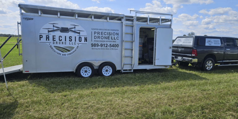
In the heart of the Great Lakes State, an agricultural revolution is quietly taking flight, driven by the cutting-edge capabilities of Precision Drone LLC. By harnessing state-of-the-art drone technology, Michigan’s farmers and conservationists are transforming traditional practices into high-tech operations that maximize efficiency and sustainability. With precision drone services, landowners can now achieve unparalleled accuracy in crop monitoring and environmental surveying, ensuring that every decision is data-driven and impactful. From aerial mapping to precision spraying, these innovative drones are redefining what it means to manage land effectively, offering solutions that are as environmentally conscious as they are technologically advanced. As Michigan agriculture embraces these advancements, a new era of farming and conservation dawns, promising a future where technology and nature work hand in hand.

Introduction to Precision Drone Services
In recent years, precision drone services have become an indispensable tool in transforming the agricultural landscape of Michigan. By integrating advanced drone technology, farmers and conservationists are equipped to maximize yield and efficiency while minimizing environmental impact. This section explores how drones are reshaping agriculture and supporting environmental initiatives.
Transforming Michigan Agriculture
Precision drone services are revolutionizing Michigan agriculture by providing new ways to monitor and manage crops. Drones enable farmers to gain insights into crop health, soil conditions, and plant growth, all from a bird’s-eye view. This transformation allows for more informed decision-making, resulting in improved farm productivity.
Farmers can now respond proactively to issues like nutrient deficiencies and pest infestations, thanks to the real-time data collected by drones. By analyzing this data, they can implement targeted solutions that enhance yield and sustainability.
Moreover, the use of drones for aerial mapping and precision spraying helps ensure that resources are used efficiently. This leads to cost savings and a reduction in the environmental footprint of farming practices.
Advantages of Drone Technology
The advantages of drone technology in agriculture are numerous and impactful. Drones provide a level of precision and efficiency previously unattainable through traditional methods. Key advantages include:
Precision Monitoring: Drones offer high-resolution imaging, allowing farmers to monitor crop health with pinpoint accuracy.
Cost Efficiency: By using drones, farmers can reduce labor and resource costs, optimizing their operations.
Environmental Benefits: Drone technology supports sustainable practices by minimizing chemical use and waste.
The integration of drones into farming operations leads to more efficient resource management and a significant reduction in environmental impact.
Supporting Environmental Management
Drones are not only changing agriculture but also enhancing environmental management. They provide essential tools for conservation efforts across Michigan. By facilitating detailed aerial surveys, drones help track wildlife, monitor habitats, and assess environmental changes.
Moreover, drones support initiatives aimed at preserving natural resources and biodiversity. They offer a non-invasive method of data collection, ensuring minimal disturbance to ecosystems.
Through these capabilities, drones play a crucial role in promoting sustainable development and conservation efforts across the region.
Advanced Crop Monitoring
The advent of advanced crop monitoring through drones has introduced a new level of precision in agriculture. This section delves into the benefits of multispectral imaging and real-time data, which are integral to improving crop yields and sustainability.
Multispectral Imaging Benefits
Multispectral imaging provides a comprehensive view of crop health by capturing data across various wavelengths. This technology enables farmers to detect subtle changes in plant conditions, which might be invisible to the naked eye.
For instance, changes in light reflection can indicate plant stress due to nutrient deficiencies or water scarcity. By identifying these issues early, farmers can intervene promptly to mitigate damage and optimize plant health.
The insights gained from multispectral imaging allow for targeted interventions, leading to increased efficiency and productivity in farming practices.
Real-Time Data for Farmers
The ability to access real-time data is one of the most significant advantages provided by drone technology. Farmers can receive up-to-the-minute information about their crops, enabling quick decision-making.
With real-time data, farmers can monitor changes in crop conditions, track growth patterns, and identify potential threats such as pest infestations. This proactive approach helps in reducing crop losses and maximizing yield.
The integration of real-time data into farming practices ensures that decision-making is always informed and timely, resulting in better outcomes for farmers.
Improving Crop Yields
Drone technology plays a vital role in improving crop yields by providing farmers with the tools they need to optimize their operations. Through precision monitoring and data analysis, farmers can enhance yield quality and quantity.
By using drones, farmers can implement targeted interventions that address specific issues affecting crop health. This leads to more efficient resource use and improved overall productivity.
The adoption of drone technology in agriculture results in significant improvements in crop yields, contributing to the sustainability and profitability of farming operations.
Precision Spraying Techniques
Precision spraying techniques enabled by drones are transforming the way chemicals are applied in agriculture. This section explores how drones reduce chemical waste, enhance application accuracy, and promote sustainable farming practices.
Reducing Chemical Waste
One of the key benefits of using drones for precision spraying is the reduction of chemical waste. Drones ensure that chemicals are applied only where needed, minimizing unnecessary use and environmental impact.
This targeted approach helps farmers save on input costs while protecting the environment from excessive chemical exposure. By reducing waste, drone technology supports more sustainable and eco-friendly farming practices.
Enhancing Application Accuracy
Drones offer unparalleled accuracy in the application of fertilizers, herbicides, and pesticides. The technology ensures even distribution across fields, resulting in consistent and effective treatment.
With drone technology, farmers can precisely control the amount and location of chemical application, reducing the risk of overuse or underuse. This precision leads to healthier crops and reduces the likelihood of resistance development in pests and weeds.
Sustainable Farming Practices
Precision spraying techniques contribute significantly to the sustainability of farming practices. By using drones, farmers can adopt methods that conserve resources and protect the environment.
The reduction in chemical use and waste supports the health of surrounding ecosystems, promoting biodiversity and soil health. Drones enable farmers to implement sustainable practices that align with modern agricultural standards.
Comprehensive Land Surveying
Comprehensive land surveying with drones offers detailed insights into terrain and infrastructure. This section discusses the benefits of 3D mapping, data-driven decision-making, and applications for land developers.
3D Mapping and Terrain Modeling
3D mapping and terrain modeling are essential tools provided by drones for land surveying. These technologies allow for accurate assessments of land features, essential for effective planning and development.
Drones capture high-resolution images that are used to create detailed 3D models of the landscape. These models provide valuable information for agricultural planning, irrigation layout, and infrastructure development.
The use of 3D mapping enables more informed decision-making and efficient resource allocation in land management.
Data-Driven Decision Making
Data-driven decision-making is at the core of effective land management. Drones provide comprehensive data that informs every aspect of land use planning and development.
With detailed insights into soil composition, terrain features, and environmental conditions, decision-makers can optimize land use strategies. This results in improved efficiency and sustainability in land management practices.
The integration of drone technology into land surveying ensures that decisions are based on accurate and reliable data, leading to better outcomes.
Applications for Land Developers
Drones offer significant benefits for land developers by providing detailed and accurate information essential for planning and development.
Some applications include:
Site Analysis: Drones provide comprehensive data for evaluating potential development sites.
Infrastructure Planning: Detailed maps and models help in designing roads, buildings, and other infrastructure elements.
Environmental Impact Assessment: Drones assess environmental conditions and potential impacts, supporting sustainable development practices.
The use of drones in land surveying enhances planning accuracy and efficiency, leading to more successful development projects.
Environmental and Conservation Efforts
Drones play a crucial role in supporting environmental and conservation efforts. This section covers non-intrusive aerial surveys, wildlife monitoring, and eco-friendly solutions.
Non-Intrusive Aerial Surveys
Non-intrusive aerial surveys conducted by drones provide vital data for conservation efforts without disturbing natural habitats. These surveys offer a bird’s-eye view of ecosystems, allowing for comprehensive environmental assessments.
Drones capture high-resolution images and videos that are used to monitor changes in wildlife populations, vegetation cover, and land use patterns. This information is invaluable for conservationists working to protect natural resources.
Through non-intrusive methods, drones support sustainable management of natural habitats and biodiversity.
Supporting Wildlife and Habitat
Drones are instrumental in supporting the monitoring and protection of wildlife and their habitats. They provide a safe and effective way to track animal movements and assess habitat conditions.
By using drones, conservationists can collect data on species distribution, migration patterns, and habitat requirements. This information is crucial for developing effective conservation strategies and policies.
Drones enable conservationists to work efficiently while minimizing the impact on wildlife and their environments.
Eco-Friendly Monitoring Solutions
Drones offer eco-friendly monitoring solutions that reduce the environmental impact of data collection and analysis. By using drones, conservationists can gather essential information with minimal resource use and disturbance.
The integration of drone technology into environmental monitoring supports sustainable practices and enhances the effectiveness of conservation efforts. Drones provide reliable and accurate data that informs policy-making and resource management decisions.
Overall, drones are a valuable tool in promoting sustainable development and environmental stewardship.