From Fields to Forests: The Impact of Drone Technology on Environmental Surveys
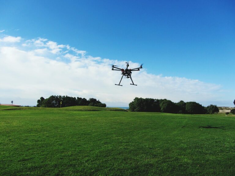
In recent years, drone technology has made remarkable strides, transforming the way we approach environmental surveys and monitoring. At the intersection of agriculture and conservation, drones are becoming indispensable tools, offering unprecedented precision and efficiency. From expansive fields to dense forests, these aerial innovations enable detailed data collection that was once labor-intensive and time-consuming. At Precision Drone LLC, we are at the forefront of this technological revolution, providing agricultural drone services that optimize crop health and manage natural resources effectively. As we delve into the impact of these advancements, we’ll explore how our solutions not only enhance environmental stewardship but also redefine agriculture drone services pricing, ensuring accessibility and sustainability for all.

Revolutionizing Agriculture with Drones
Drones are reshaping the agricultural landscape by enhancing efficiency and precision in farming practices. These aerial tools empower farmers with detailed insights and data that were previously inaccessible. In this section, we explore how drones are revolutionizing agriculture through various advancements and applications.
Advancements in Aerial Monitoring
Drone technology has significantly advanced, offering farmers enhanced capabilities for monitoring their crops. Aerial monitoring facilitates the collection of high-resolution images and data, enabling precise analysis of crop conditions. This technology helps identify issues such as disease, pest infestations, and water stress, allowing for timely interventions.
Offering a bird’s-eye view, drones can cover large agricultural areas quickly and efficiently. Compared to traditional methods, drones reduce the time and labor required for monitoring, leading to cost savings and increased productivity. By utilizing drones, farmers can optimize resource use and minimize environmental impact.
Moreover, drones equipped with multispectral sensors provide insights beyond the visible spectrum. By analyzing different wavelengths of light, they can identify plant health indicators that are invisible to the naked eye. This capability enables early detection of anomalies, ensuring prompt corrective measures.
Precision in Crop Health Optimization
Precision agriculture relies heavily on drones for optimizing crop health. Drones equipped with advanced sensors deliver precise data on soil conditions, nutrient levels, and crop health. This information guides farmers in making data-driven decisions to improve yields and reduce waste.
Step by step process for crop health optimization with drones:
-
Data Collection: Drones capture high-resolution images and sensor data.
-
Analysis: Software processes the data, highlighting areas of concern.
-
Intervention: Farmers apply targeted treatments based on insights.
Through this process, farmers can tailor interventions to specific areas, minimizing the use of fertilizers and pesticides. This not only reduces costs but also benefits the environment by lowering chemical runoff.
Moreover, drones enable the monitoring of crop growth stages, allowing farmers to adjust practices according to plant development. By ensuring optimal growth conditions, farmers can enhance both yield and quality, ultimately boosting profitability.
Enhancing Agricultural Productivity
The integration of drones into agriculture has led to significant productivity gains. By providing accurate data and insights, drones empower farmers to make informed decisions that enhance farm efficiency. Real-world examples demonstrate the impact of drone technology on productivity.
For instance, a farm utilizing drones for crop monitoring reported a 20% increase in yield due to timely interventions. The ability to identify and address issues early resulted in healthier crops and higher profits.
Key insights from such cases include:
-
Efficient resource use through targeted interventions.
-
Reduced labor costs due to automated monitoring.
-
Improved crop quality and yield through precise management.
By leveraging drone technology, farmers can maximize their outputs while minimizing inputs. This not only enhances profitability but also contributes to sustainable agricultural practices.
Conservation Efforts and Drone Technology
While drones are revolutionizing agriculture, their impact extends beyond farming. In conservation, drones play a critical role in resource management, wildlife monitoring, and supporting environmental sustainability. This section delves into how drones are transforming conservation efforts.
Comprehensive Surveys for Resource Management
Drones have become invaluable tools for conducting comprehensive environmental surveys. Equipped with advanced imaging technologies, drones can map large areas with precision, aiding in resource management and planning.
For example, in forestry, drones are used to assess tree health and identify areas impacted by disease or pests. This data-driven approach enables targeted interventions, reducing the spread of disease and promoting forest health.
Key benefits of drone surveys include:
-
High-resolution mapping for accurate assessments.
-
Rapid data collection over large areas.
-
Cost-effective compared to traditional surveying methods.
By utilizing drones for resource management, conservationists can make informed decisions that promote sustainability and biodiversity.
Innovations in Wildlife Monitoring
Wildlife monitoring has been greatly enhanced by drone technology. Drones provide a non-intrusive way to observe wildlife, minimizing human disturbance and capturing natural behaviors. This technology is especially valuable in remote or inaccessible areas.
Real-world example: A conservation project used drones to monitor endangered species, gathering data on population sizes and movements. The insights gained informed conservation strategies, resulting in measures that supported species recovery.
Key insights include:
-
Non-invasive monitoring preserving natural habitats.
-
Improved data accuracy and timeliness.
-
Enhanced ability to track and protect endangered species.
Through innovations in wildlife monitoring, drones contribute to the conservation of biodiversity and the protection of ecosystems.
Supporting Environmental Sustainability
Drones are pivotal in promoting environmental sustainability by facilitating efficient resource use and reducing environmental impact. Agricultural drone services enable precise applications of inputs, minimizing waste and pollution.
Actionable advice for sustainable practices with drones includes:
-
Implementing precision agriculture to reduce chemical use.
-
Utilizing drones for reforestation and habitat restoration.
-
Monitoring environmental changes to adapt conservation strategies.
By supporting sustainable practices, drones help balance human needs with ecological preservation, fostering a healthier planet for future generations.
Economic Impact of Drone Services
The economic implications of drone technology are vast, affecting both costs and benefits in agriculture and conservation. This section examines how drones impact pricing, cost-efficiency, and long-term financial outcomes.
Understanding Agriculture Drone Services Pricing
The cost of agricultural drone services varies based on factors such as technology complexity, service scope, and geographic location. Understanding these pricing structures is crucial for farmers considering drone adoption.
Factors influencing pricing:
-
Equipment and Technology: Advanced sensors and cameras increase costs.
-
Service Scope: Larger areas or detailed analyses may incur higher fees.
-
Location: Accessibility and local regulations can affect pricing.
Farmers must weigh these factors to determine the value of drone services. While initial costs may seem high, the long-term benefits often outweigh expenses, making drones a viable investment.
Cost-Benefit Analysis of Drone Technologies
Conducting a cost-benefit analysis is essential for evaluating the financial viability of drone technology. This involves comparing the costs of implementation with the potential benefits in terms of yield improvement, resource savings, and environmental impact.
Steps in cost-benefit analysis:
-
Identify Costs: Equipment purchase, service fees, and maintenance.
-
Estimate Benefits: Increased yield, reduced inputs, and enhanced quality.
-
Compare Outcomes: Calculate the return on investment over time.
By quantifying the economic impact, farmers can make informed decisions about integrating drones into their operations. The analysis often reveals significant financial and ecological advantages.
Long-Term Savings and Efficiency
Over the long term, drones offer substantial savings and efficiency gains. By optimizing resource use and reducing labor costs, drones enhance profitability and sustainability.
Data-driven insights:
-
30% reduction in fertilizer use through precision applications.
-
40% decrease in labor costs due to automated monitoring.
-
25% increase in crop yield from improved management.
These savings contribute to a stronger bottom line and a more sustainable agricultural model. By investing in drone technology, farmers position themselves for long-term success and resilience.
Challenges and Considerations in Drone Use
Despite their benefits, drones present certain challenges and considerations. Regulatory compliance, technological limitations, and data security are critical factors for successful drone integration. This section addresses these concerns and offers guidance.
Regulatory Framework and Compliance
Operating drones requires adherence to a complex regulatory framework. Compliance with local and national regulations ensures safe and legal drone use.
Key regulatory considerations:
-
Licensing: Pilots may need certification or training.
-
Airspace Restrictions: Some areas may have flight limitations.
-
Privacy Laws: Ensuring data collection respects privacy rights.
Farmers and conservationists must stay informed about regulations to avoid legal issues. Collaboration with regulatory bodies can facilitate smoother drone operations.
Overcoming Technological Limitations
While powerful, drone technology has limitations such as battery life, weather dependency, and data processing capacity. Overcoming these challenges is crucial for maximizing drone utility.
Strategies to address limitations:
-
Investing in drones with longer battery life.
-
Scheduling flights in optimal weather conditions.
-
Using advanced software for efficient data processing.
By addressing these technological constraints, users can enhance the effectiveness and reliability of drone operations.
Ensuring Data Security and Privacy
Data security and privacy are paramount in drone operations. Protecting sensitive data is essential to maintain trust and comply with regulations.
Steps to ensure data security:
-
Encrypt Data: Use secure protocols for data transmission.
-
Access Control: Limit data access to authorized personnel.
-
Regular Audits: Conduct security assessments to identify vulnerabilities.
Implementing robust security measures safeguards data integrity and builds confidence in drone technology.
Future of Drone Technology in Environmental Surveys
As drone technology evolves, its future applications in environmental surveys are expanding. Emerging trends, new applications, and sustainable development are shaping the next wave of innovations.
Emerging Trends in Drone Innovations
Rapid advancements in drone technology are paving the way for new capabilities and applications. Enhanced sensors, artificial intelligence, and autonomous flights are among the emerging trends.
Innovations to watch:
-
AI Integration: Enabling autonomous data analysis.
-
Advanced Sensors: Capturing higher-quality data.
-
Swarm Technology: Coordinating multiple drones for larger surveys.
These innovations promise to make drones even more integral to environmental monitoring and management.
Expanding Applications Beyond Agriculture
Beyond agriculture, drones offer potential in various fields such as urban planning, disaster response, and infrastructure inspection. This expansion broadens the scope of drone applications.
Real-world examples:
-
Monitoring urban green spaces for planning and development.
-
Assessing damage and coordinating relief efforts in disaster-affected areas.
-
Inspecting critical infrastructure like bridges and power lines.
By exploring these applications, drones contribute to diverse sectors, enhancing efficiency and safety.
Vision for Sustainable Development
Drones hold the potential to advance sustainable development goals by promoting efficient resource use and environmental conservation. By aligning technology with sustainability, drones can support a healthier planet.
Actionable strategies:
-
Integrate drones into reforestation and habitat restoration projects.
-
Use drones for efficient waste management and pollution monitoring.
-
Collaborate with communities to implement sustainable practices.
With a focus on sustainability, drones can drive positive change and support long-term environmental health.