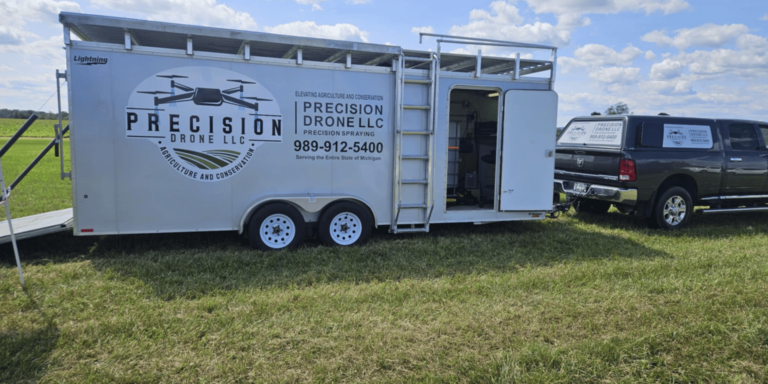
Precision Drone LLC’s Guide to Agricultural Drone Service and Pricing in Michigan
In the heart of Michigan’s vibrant farming community, Precision Drone LLC is transforming how agriculture and conservation are approached with state-of-the-art drone technology. Our agricultural drone services provide farmers and conservationists with tools for precise monitoring, enabling optimized crop health and effective resource management. By delivering targeted applications and comprehensive surveys, we empower our clients to enhance efficiency and sustainability in their operations. With a commitment to innovation and reliability, we bring unparalleled accuracy to Michigan’s agricultural and environmental sectors, offering transparent agriculture drone services pricing that aligns with the unique needs of each project. Join us as we explore the benefits and pricing of these revolutionary services, designed to elevate productivity and conservation efforts across the state.

Overview of Agricultural Drone Services
Agricultural drone services are transforming traditional farming methods in unprecedented ways. These technologies bring precision, efficiency, and a new level of insight to agriculture. In this section, we explore how drones are revolutionizing agriculture, enhancing conservation efforts, and providing precise monitoring solutions.
Revolutionizing Agriculture with Drones
The integration of drones into agriculture marks a significant shift in farming practices. Drones offer a new perspective on crop health by providing aerial views that are unattainable from the ground. This bird’s-eye view allows for early detection of issues such as pest infestations or water stress.
Drones equipped with multispectral cameras can capture detailed images that reveal variations in crop health. Farmers can use this data to make informed decisions about irrigation and fertilization.
Additionally, drones streamline the process of collecting data. Instead of spending hours manually inspecting fields, farmers can deploy drones to gather the necessary information quickly and accurately.
Enhancing Conservation Efforts
Drones are not only beneficial for agriculture but also play a crucial role in conservation. They help monitor wildlife populations and track changes in habitats without disturbing the natural environment.
By using drones, conservationists can cover large areas of land quickly. This capability is particularly useful in tracking endangered species or monitoring protected areas.
Drones also facilitate the collection of data in hard-to-reach locations. This accessibility ensures that conservation efforts are informed by comprehensive and accurate data, leading to more effective strategies.
Precision and Efficiency in Monitoring
Precision in monitoring is a standout feature of drone technology. Drones provide detailed information that is critical for effective crop management.
With high-resolution cameras and sensors, drones capture data with unparalleled accuracy. This precision enables farmers to target specific areas that need attention, optimizing resource use.
Moreover, drones offer a time-efficient solution. They can cover large fields in a fraction of the time it would take using traditional methods. This efficiency allows for frequent monitoring, ensuring that any issues are addressed promptly.
Key Drone Technologies Used
The effectiveness of agricultural drone services is largely due to the advanced technologies they employ. This section delves into the aerial solutions, survey techniques, and application systems that make drones indispensable tools in modern agriculture.
Advanced Aerial Solutions
Drones used in agriculture are equipped with cutting-edge technology tailored for various tasks. These aerial solutions provide farmers with the tools needed to maximize yield and minimize waste.
Multispectral and hyperspectral imaging are key technologies that enhance the capabilities of agricultural drones. These imaging techniques allow for detailed analysis of plant health.
Additionally, thermal imaging sensors help identify areas of heat stress or water deficiency. This data is crucial for maintaining optimal crop conditions and preventing yield loss.
Comprehensive Survey Techniques
Comprehensive surveys are essential for informed agricultural decision-making. Drones streamline this process with their ability to cover large areas quickly and accurately.
Drones employ LiDAR and photogrammetry for precise mapping and data collection. These technologies generate detailed topographical maps and 3D models, offering insights into field conditions.
Survey data collected by drones can be integrated with Geographic Information Systems (GIS). This integration allows for advanced spatial analysis, crucial for precision agriculture practices.
Targeted Application Systems
Targeted application systems are revolutionizing how fertilizers and pesticides are applied. Drones ensure that these applications are precise, reducing waste and environmental impact.
Variable rate technology (VRT) enables drones to adjust the amount of material applied based on real-time data. This precision ensures that crops receive the exact nutrients they need.
Drones can also apply fertilizers and pesticides in challenging terrains. Their agility and precision make them ideal for targeting specific areas, leading to more efficient resource use.
Pricing Structure for Drone Services
Understanding the pricing structure for drone services is crucial for farmers looking to integrate these technologies into their operations. In this section, we examine the factors influencing service costs, provide a detailed breakdown of pricing, and explore cost-effective solutions tailored for farmers.
Factors Influencing Service Costs
Several factors influence the cost of agricultural drone services. Understanding these factors helps farmers make informed decisions.
-
Type of Service Provided: Different services, such as surveying, mapping, or spraying, carry different costs.
-
Technology Used: Advanced sensors and cameras can increase service costs but also offer more detailed data.
-
Field Size and Complexity: Larger or more complex fields may require more time and resources, affecting pricing.
Service frequency is another consideration. Regular monitoring might lead to different pricing structures compared to one-time services.
Detailed Breakdown of Pricing
A detailed breakdown of pricing helps in understanding the investment required for drone services. Typically, pricing is based on the complexity and scope of the service.
|
Service Type |
Cost Range |
Inclusions |
|---|---|---|
|
Basic Monitoring |
$200 – $500 |
Aerial imagery, basic analysis |
|
Advanced Surveying |
$500 – $1,000 |
Detailed mapping, multispectral imaging |
|
Targeted Application |
$300 – $700 |
Fertilizer/pesticide application |
These prices reflect typical ranges and can vary based on specific needs and conditions.
Cost-Effective Solutions for Farmers
Cost-effective solutions are available to ensure that drone services are accessible to farmers of all scales. These solutions focus on maximizing value while minimizing expenditure.
-
Subscription Services: Regular monitoring at reduced rates
-
Customized Packages: Tailored services that fit specific needs
-
Lease Options for Equipment: Access to drones without high upfront costs
These options provide flexibility and affordability, making advanced technology accessible to a broader range of farmers.
Benefits of Using Drone Services
The benefits of using drone services in agriculture are manifold. This section highlights how drones optimize crop health, assist in resource management, and facilitate critical surveys.
Optimizing Crop Health
Drones play a pivotal role in optimizing crop health by providing detailed insights into plant conditions. Early detection of issues leads to timely interventions and better yield outcomes.
High-resolution cameras capture images that reveal subtle changes in plant health. These images are analyzed to identify stress factors such as nutrient deficiencies or pest infestations.
Farmers can then implement targeted solutions, such as precise fertilization or pest control measures. This precision not only enhances crop health but also improves overall productivity.
Managing Natural Resources
Effective management of natural resources is crucial for sustainable agriculture. Drones assist in this by offering detailed data on soil and water conditions.
Drones equipped with sensors provide information on soil moisture levels and irrigation needs. This data allows farmers to optimize water use, conserving resources while maintaining crop health.
Additionally, drones help monitor soil erosion and nutrient levels, ensuring that resource management practices are sustainable and effective.
Conducting Critical Surveys
Conducting critical surveys is streamlined with drone technology. These surveys provide essential data for planning and decision-making in agriculture.
Drones quickly cover large areas, gathering data that would take much longer through traditional methods. This efficiency allows for regular surveys, ensuring that farmers have up-to-date information.
Surveys conducted by drones provide insights into field conditions, helping farmers plan planting schedules and resource allocation more effectively.
Supporting Michigan’s Agriculture Sector
Precision Drone LLC is committed to supporting Michigan’s agriculture sector through innovative and tailored solutions. This section explores how we provide bespoke services for local farmers, enhance productivity, and uphold environmental responsibility.
Tailored Solutions for Local Farmers
We understand the unique challenges faced by Michigan farmers and offer tailored solutions to meet their needs. These solutions ensure that farmers receive the most relevant and effective services.
By collaborating with local experts, we design services that address specific regional concerns. This collaboration ensures that our technology is applied in the most effective way possible.
Farmers benefit from personalized service packages, which are adapted to the diverse agricultural landscape of Michigan.
Enhancing Productivity and Sustainability
Enhancing productivity and sustainability is at the core of our mission. Our drone services help farmers increase yield while minimizing environmental impact.
Through precise monitoring and targeted interventions, we enable farmers to use resources more efficiently. This efficiency leads to higher productivity and more sustainable farming practices.
Our commitment to sustainability ensures that our services not only benefit farmers but also support broader environmental goals.
Commitment to Environmental Responsibility
Environmental responsibility is a fundamental aspect of our operations. We strive to provide services that respect and preserve the natural environment.
By reducing pesticide and fertilizer use through targeted application, we minimize the ecological footprint of farming practices. This reduction is crucial for maintaining biodiversity and healthy ecosystems.
We also offer services that help monitor and protect natural habitats, reinforcing our commitment to environmental stewardship.