Affordable Innovation: Understanding Agriculture Drone Services Pricing with Precision Drone LLC
In the ever-evolving landscape of agriculture, staying ahead means embracing technology that boosts efficiency and sustainability. Precision Drone LLC is at the forefront of this revolution, offering affordable and innovative agricultural drone services that transform how crops are monitored and managed. By providing precise monitoring and targeted applications, we empower farmers and conservationists alike to make informed decisions that maximize yield and preserve natural resources. As the demand for advanced aerial solutions grows, understanding agriculture drone services pricing becomes crucial for those looking to integrate these cutting-edge tools into their operations. Join us as we delve into the world of drone technology and uncover how Precision Drone LLC is making top-tier services accessible to everyone in Michigan’s agricultural and environmental sectors.
Introduction to Agricultural Drone Services
The integration of drone technology into agriculture has marked a significant shift in how farming is approached. This section explores the rise of drone technology, its benefits for agriculture, and Precision Drone LLC’s mission.
The Rise of Drone Technology
Drone technology has rapidly evolved, becoming an indispensable tool in various industries, including agriculture. Initially used for military and recreational purposes, drones now play a pivotal role in enhancing agricultural practices. They offer a bird’s-eye view of fields, allowing for detailed monitoring and surveillance. Agricultural drones are equipped with advanced sensors and imaging capabilities that provide critical data on crop health, soil conditions, and more.
As the technology progresses, drones are becoming more affordable and accessible. This shift has led to widespread adoption among farmers seeking to optimize their operations. Furthermore, the integration of artificial intelligence and machine learning with drones is set to improve data analysis, offering even more precise insights.
To learn more about the impact of drone technology in agriculture, consider visiting this resource.
Benefits of Aerial Solutions in Agriculture
Aerial solutions provided by drones offer several advantages over traditional methods. Firstly, they enhance efficiency. Drones can cover large areas quickly, reducing the time and labor needed for field inspections. This rapid data collection is crucial for timely interventions.
Secondly, drones offer precision. With high-resolution cameras and sensors, they detect issues at an early stage, allowing for targeted treatments. This precision helps in minimizing resource usage, reducing costs, and promoting sustainable practices.
Lastly, drones support data-driven decision-making. By providing real-time data, farmers can make informed decisions about planting, irrigation, and pest control. This leads to improved crop yields and profitability.
Explore the benefits of aerial solutions further by visiting this link.
Precision Drone LLC’s Mission and Vision
Precision Drone LLC is dedicated to revolutionizing agriculture through cutting-edge drone technology. Our mission is to provide affordable, high-quality agricultural drone services that enhance productivity and sustainability. We aim to empower farmers with the tools they need to maximize yields and preserve natural resources.
Our vision extends beyond just providing services. We seek to educate and support the agricultural community in adopting these technologies. By fostering a collaborative approach, we ensure that our clients are equipped to face the challenges of modern agriculture.
For more about our mission and the impact of our work, visit our website.
Understanding Agriculture Drone Services Pricing
This section delves into the pricing aspects of agricultural drone services, highlighting the factors influencing pricing, the cost-benefit analysis for farmers, and the transparency offered by Precision Drone LLC.
Factors Influencing Pricing
Understanding agriculture drone services pricing involves considering multiple factors. Firstly, the type of drone and its capabilities significantly affect costs. Advanced drones with sophisticated sensors and cameras are generally more expensive.
Secondly, the scope of services impacts pricing. Comprehensive packages that include data analysis, mapping, and reporting tend to be priced higher. Additionally, the size and location of the farm can influence costs, as larger areas or remote locations may require more resources.
Lastly, ongoing support and maintenance can affect pricing. Services that offer robust customer support and regular updates might be priced at a premium but offer long-term value.
For a detailed breakdown of pricing factors, check out this resource.
Cost-Benefit Analysis for Farmers
Conducting a cost-benefit analysis is essential for farmers considering drone services. The initial investment might seem significant, but the long-term benefits often outweigh the costs.
Benefits include increased yields due to precise interventions and reduced input costs from optimized resource use. Drones enable farmers to detect issues early, leading to timely solutions that prevent crop losses.
Moreover, the data-driven insights provided by drones can improve decision-making, resulting in more efficient operations. This efficiency translates into higher profitability and sustainability.
For an in-depth analysis of the benefits, refer to this link.
Pricing Transparency at Precision Drone LLC
At Precision Drone LLC, we prioritize pricing transparency. We believe in clear, straightforward pricing structures that allow clients to understand the value they receive. Our pricing models are designed to be flexible, catering to various needs and budgets.
We offer detailed quotes that outline the cost components, ensuring there are no hidden fees. Our team is always ready to discuss and customize packages to fit specific requirements.
By maintaining transparency, we build trust with our clients, fostering long-term relationships. For more information on our pricing policies, visit our site.
Revolutionizing Crop Management
This section discusses how drones are transforming crop management through optimizing health and yield, targeted pest control applications, and precision surveying for resource management.
Optimizing Crop Health and Yield
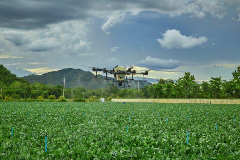
Drones play a crucial role in optimizing crop health and maximizing yields. Equipped with multispectral sensors, drones capture detailed images that reveal crop conditions unseen to the naked eye. These images help identify issues like nutrient deficiencies, pest infestations, or water stress early on.
Farmers can utilize this data to make targeted interventions, applying fertilizers or pesticides precisely where needed, reducing waste, and saving costs. This targeted approach not only improves crop health but also enhances yields.
Moreover, drones facilitate better irrigation management by mapping fields and identifying areas that require more or less water. This precision leads to more efficient water use and healthier crops.
To explore these applications further, visit this resource.
Targeted Applications for Pest Control
Pest control is essential for maintaining healthy crops, and drones offer a precise solution. With advanced imaging, drones can detect early signs of pest activity, allowing for timely interventions.
-
Detection: Drones fly over fields, capturing images that reveal pest hotspots.
-
Analysis: The data collected is analyzed to identify the type and extent of infestation.
-
Application: Drones can then apply pesticides directly to affected areas, ensuring minimal impact on the environment.
This targeted approach reduces chemical use and prevents crop damage, contributing to sustainable farming practices.
For more on how drones are revolutionizing pest control, check out this link.
Precision Surveying for Resource Management
Drones enable precision surveying, crucial for effective resource management. They provide detailed topographical maps, allowing farmers to understand field variations and optimize land use.
These surveys help in planning efficient planting patterns, managing water resources, and mitigating soil erosion. By understanding the land better, farmers can make informed decisions that enhance productivity.
Furthermore, drones can monitor soil health by measuring parameters like moisture levels and nutrient content, contributing to better soil management practices.
For detailed insights into precision surveying, visit our website.
Enhancing Conservation Efforts
Drones are not just transforming agriculture; they are also enhancing conservation efforts. This section explores how drones monitor natural resources, support environmental sustainability, and showcase successful implementation case studies.
Monitoring Natural Resources with Drones
Drones are instrumental in monitoring natural resources. They provide real-time data on forests, wetlands, and other ecosystems, crucial for conservation efforts.
With high-resolution cameras and sensors, drones capture images and data that help track changes in land use, forest cover, and biodiversity. This information is vital for assessing the impact of human activities and natural events on ecosystems.
Moreover, drones can access remote or hazardous areas, making them invaluable for conservationists. By offering a comprehensive view of natural resources, drones enable more effective conservation strategies.
To learn more about these monitoring capabilities, explore this link.
Supporting Environmental Sustainability
Environmental sustainability is a key focus of drone technology. Drones support sustainable practices by minimizing resource use and reducing environmental impact.
-
Efficient Resource Use: By providing precise data, drones reduce the need for excessive water, fertilizers, and pesticides.
-
Biodiversity Monitoring: Drones track wildlife and habitat changes, aiding in biodiversity conservation.
-
Carbon Footprint Reduction: By optimizing operations, drones help lower the carbon footprint of agricultural activities.
These contributions make drones a vital tool for promoting sustainability in agriculture and beyond.
For more on sustainability efforts, visit our site.
Case Studies of Successful Implementation
The successful implementation of drone technology in agriculture and conservation is evident in numerous case studies. These examples highlight the tangible benefits and transformative potential of drones.
Case Study 1: A Michigan farm reduced water usage by 30% through drone-assisted irrigation management.
-
Improved water efficiency
-
Increased crop yield
Case Study 2: A conservation project used drones to monitor and protect wildlife habitats, leading to a 20% increase in biodiversity.
-
Enhanced habitat protection
-
Increased species diversity
These cases showcase how drones drive innovation and sustainability. For more examples, check out this resource.
Future of Drone Services in Agriculture
As technology advances, the future of drone services in agriculture promises exciting developments. This section discusses upcoming technological advancements, the expansion of services beyond agriculture, and Precision Drone LLC’s commitment to innovation.
Technological Advancements on the Horizon
The future of agricultural drone service is set to be shaped by technological advancements. New developments in drone technology promise enhanced capabilities and efficiencies.
The integration of artificial intelligence and machine learning will enable drones to analyze data autonomously, providing real-time insights into crop health and environmental conditions. Additionally, improvements in battery life and range will allow drones to cover larger areas, offering even more comprehensive monitoring.
As these technologies evolve, drones will become even more integral to agricultural and conservation efforts, driving innovation and sustainability.
For insights into future technologies, explore this link.
Expanding Services Beyond Agriculture
While drones have revolutionized agriculture, their potential extends far beyond. Drones are finding applications in industries like construction, real estate, and environmental monitoring.
-
Construction: Drones provide aerial surveys for site planning and progress monitoring.
-
Real Estate: High-resolution images and videos enhance property listings and marketing.
-
Environmental Monitoring: Drones track environmental changes and support conservation efforts.
These diverse applications highlight the versatility of drones and their potential to drive innovation across sectors.
For more on expanding drone services, visit our website.
Precision Drone LLC’s Commitment to Innovation
At Precision Drone LLC, we are committed to innovation and growth. Our focus is on developing cutting-edge solutions that meet the evolving needs of our clients.
We continuously invest in research and development to enhance our services and stay ahead of industry trends. Our team works closely with clients to understand their challenges and tailor solutions that deliver results.
By fostering a culture of innovation, we aim to lead the way in transforming agriculture and conservation through drone technology.
For more about our commitment to innovation, check out our site.


