Transforming Farming and Conservation: How Precision Drone LLC is Leading the Way in Michigan
In the heart of Michigan, where agriculture and natural landscapes intertwine, Precision Drone LLC is pioneering a new era of farming and conservation. By integrating state-of-the-art drone technology into traditional practices, we are setting new standards for efficiency and sustainability across the region. Our agricultural drone services provide precise monitoring and targeted applications that enable farmers to optimize crop health and resource management with unprecedented accuracy. Furthermore, our comprehensive surveys empower conservationists to protect and preserve Michigan’s natural beauty. Join us as we explore how our innovative approach is transforming the landscape of agriculture and conservation, offering unparalleled solutions that prioritize both productivity and environmental stewardship.
Revolutionizing Agriculture with Drones
The use of drones in agriculture is transforming traditional farming practices. These high-tech tools provide innovative solutions for monitoring crop health and optimizing resource management. Precision Drone LLC leverages such technology to usher in a new age of farming efficiency and sustainability.
Precision Monitoring Techniques
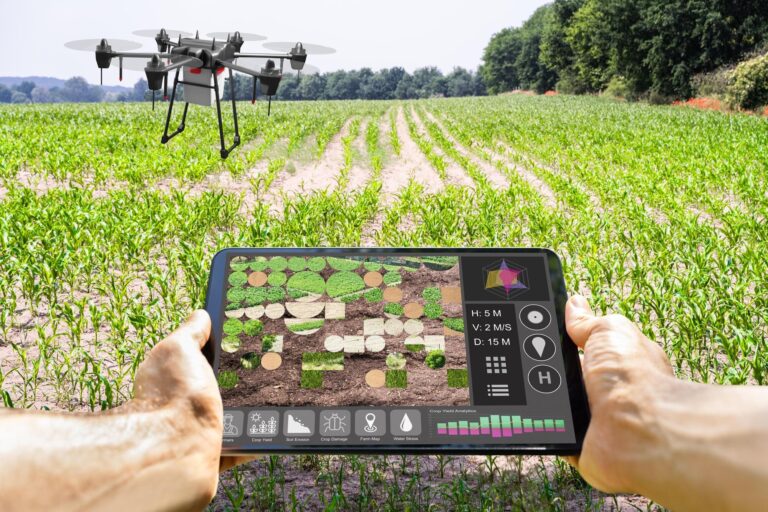
Precision monitoring with drones allows farmers to oversee vast expanses of land with incredible accuracy. By capturing high-resolution imagery, drones can detect subtle changes in plant health before they become visible to the naked eye. This enables early intervention, minimizing crop loss.
In addition, drones equipped with sensors measure variables like soil moisture and nutrient levels. This data provides insights for targeted interventions, ensuring crops receive exactly what they need. The result is more efficient use of resources.
Finally, by tracking crop progress through the growing season, farmers can make informed decisions about planting and harvesting. This can lead to better yields and a more sustainable approach to agriculture.
Benefits of Targeted Applications
Drones facilitate targeted applications of fertilizers and pesticides, which offer multiple benefits. By applying these substances only where needed, farmers reduce waste and lower costs, leading to environmental and financial gains.
Moreover, this precision reduces the risk of overapplication, which can harm the environment. It ensures that only the necessary amount of chemicals is used, promoting healthier ecosystems.
Additionally, targeted applications mean less labor and time spent applying treatments. This efficiency allows farmers to focus on other critical areas of their operations, enhancing overall productivity.
Agriculture Drone Services Pricing
Understanding the cost of drone services is crucial for farmers considering this technology. Agriculture drone services pricing can vary based on several factors:
-
Service Scope: Comprehensive packages that include monitoring, mapping, and targeted applications may cost more than basic services.
-
Frequency of Service: Regular monitoring services can come with a subscription model, offering cost-effective solutions in the long run.
-
Customization: Tailored services to meet specific farming needs may influence pricing.
Farmers should evaluate their specific needs and consult providers to find a solution that aligns with their budget and operational goals.
Enhancing Conservation Efforts
Drone technology also plays a pivotal role in conservation efforts. By offering detailed surveys and data collection for natural environments, drones help conservationists manage resources effectively and protect ecosystems.
Sustainable Resource Management
Sustainable resource management is vital for maintaining ecological balance. Drones help monitor natural resources like forests and water bodies by collecting real-time data on their conditions.
This data allows conservationists to make timely interventions when resources are threatened. For example, drones can detect illegal logging or changes in water quality, prompting immediate action.
Moreover, drones contribute to long-term strategies by providing historical data trends. These insights enable conservationists to develop informed plans that balance human needs with environmental protection.
Comprehensive Environmental Surveys
Environmental surveys conducted by drones offer a comprehensive view of ecosystems. These surveys provide high-resolution data that can be analyzed to understand species distribution and habitat health.
With aerial imagery, conservationists can monitor changes over time, such as deforestation or habitat fragmentation. This information is crucial for implementing conservation measures to preserve biodiversity.
Furthermore, drones can access hard-to-reach areas, collecting data that might otherwise be unavailable. This comprehensive view aids in creating effective conservation strategies and informing policy decisions.
Advanced Aerial Solutions for Farmers
Precision Drone LLC provides farmers with advanced aerial solutions to enhance productivity. From optimizing crop health to creating detailed maps, these services improve farming efficiency.
Optimizing Crop Health
Optimizing crop health is a primary concern for farmers, and drones offer unparalleled assistance in this area. By using multispectral cameras, drones can capture images that reveal plant vigor and detect stress early.
These insights enable timely interventions, such as adjusting irrigation or applying nutrients. Farmers can thus prevent potential issues before they escalate, ensuring healthier crops.
Moreover, drones provide a bird’s-eye view of fields, identifying areas that require more attention. Regular monitoring helps maintain optimal growing conditions, resulting in better yields.
Precision Mapping for Efficiency
Precision mapping with drones provides detailed topographic data critical for efficient farm management. High-resolution maps assist farmers in understanding field variability and tailoring practices accordingly.
Drones create accurate maps of field boundaries, irrigation systems, and crop rows. This information helps optimize planting patterns and resource allocation, enhancing efficiency.
Additionally, precision mapping aids in identifying problem areas, such as drainage issues or soil compaction. Addressing these challenges leads to more effective land use and improved productivity.
Supporting Michigan’s Agricultural Sector
Precision Drone LLC is committed to supporting Michigan’s agricultural sector through innovative solutions tailored to local needs. Our services help farmers navigate the challenges of modern agriculture.
Innovations in Local Farming
Innovations in local farming are essential for staying competitive. Drones introduce new possibilities, from data-driven decision-making to automation that reduces labor costs.
By adopting drone technology, Michigan farmers can improve crop management and operational efficiency. This technological edge helps them remain competitive in a global market.
Moreover, local farmers benefit from tailored drone solutions that address specific regional challenges. These innovations contribute to sustainable practices and long-term success.
Tailored Solutions for Michigan Farmers
Precision Drone LLC offers tailored solutions for Michigan farmers. We understand the unique needs of the region and provide services designed to enhance productivity and sustainability.
Our team works closely with farmers to develop customized plans that integrate seamlessly into their operations. We ensure that our services align with their goals and budget, providing them with the best possible outcomes.
By offering personalized support and cutting-edge technology, we empower Michigan farmers to thrive in an ever-evolving agricultural landscape.
Future of Drone Technology in Conservation
The future of drone technology in conservation holds great promise. As technology advances, new opportunities arise for preserving natural resources and biodiversity.
Emerging Trends and Opportunities
Emerging trends in drone technology offer conservationists new opportunities. Innovations like AI integration and improved sensors enhance data collection and analysis.
These advancements enable more precise monitoring of ecosystems, leading to better-informed conservation strategies. As drone technology becomes more accessible, its application in conservation is likely to expand.
Moreover, collaboration between tech companies and conservationists can drive further innovation. By working together, they can develop cutting-edge solutions that address pressing environmental challenges.
Challenges and Solutions in Implementation
Implementing drone technology in conservation comes with challenges, such as regulatory hurdles and technical limitations. However, solutions are emerging to address these issues.
-
Regulations: Working with authorities to establish clear guidelines ensures compliance and safe drone operation.
-
Technical Skills: Providing training programs equips conservationists with the skills needed to operate drones effectively.
-
Cost: Developing cost-effective solutions makes drone technology accessible to more conservation organizations.
By overcoming these challenges, drones can become an integral tool in conservation efforts, contributing to the protection and preservation of our planet’s natural resources.


![A Comprehensive Look at the Use of Drones in Agriculture [Download PDF]](https://precisiondronellc.net/wp-content/uploads/2025/09/featured-image-1757196911-768x432.jpeg)
